“A harsh winter” expected in the northern hemisphere? “After an abnormally hot year” is what Mac Lesggy, the famous host of e = M6, also an agricultural engineer. To support his point, he shares the publication of a certain Heinrich Leopold, who claims to be a chemical engineer. Several cards that seem to illustrate a cold snap accompany the post.
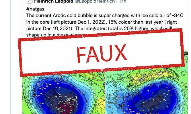
Here is the translation of what Heinrich Leopold wrote on Twitter: “The current Arctic cold bubble is overloaded with icy air of -84 ° C in the core (left photo December 1, 2022), 15% colder than the last year (pictured right December 10, 2021). The integrated total is 25% higher, which will turn into a mega winter. An exact reflection? 20 minutes make the point.
FAKE OFF
Christophe Cassou, climatologist and research director at the CNRS, hastened to respond to the famous presenter : “Everything is false in this Fake news relayed by high visibility accounts claiming to carry scientific facts with rigor. He detailed his accusation explaining that “everything, not only the predictability of winter by stratospheric temperature but also the dyn explanation. extreme heat from Oct/Nov. »
Mac Lessgy corrected itself, a few hours after its first publication : “@GaetanHeymes from #Météo-France informs me that this forecast is not based on anything, so I am deleting the related tweet. Let’s hope he’s right… This year especially, we don’t need a harsh winter. »
Colder Stratosphere Doesn’t Mean Colder Winter
Indeed, the forecasting engineer and snow scientist at Météo-France, Gaétan Heymes, also denounced false information on its social networks. “I see this tweet everywhere, relayed by journalists or even “scientific popularizers”. So it is the temperature of the stratosphere, which logically cools above the Arctic due to the progression of the polar night, ”he explained.
And to add: “We are talking about a temperature at 10 hPa”, which is equivalent to 35 km above the ground, in the stratosphere. However, weather phenomena occur in the troposphere, between the ground and an altitude of around 10 km. “This ultra-simplistic reasoning ‘colder stratosphere than last year = colder winter this year’, is really degree 0 of scientific rigor”, he says.
The specialist also explains that there are teleconnections between the stratosphere and the troposphere, but he questions the qualification of the chemical engineer to “correctly understand” this information. The latter has also repeatedly made climatosceptic remarks.
What estimates for this winter?
Meteo France presents forecasts for the next three months, November, December and January 2023 the most likely scenario is “the predominance of anticyclonic conditions, with calm and dry weather, on the European continent”. According to them, the disturbances will tend to be rejected more to the north of Europe or to the south-west of the Mediterranean.
These forecasts suggest temperatures close to climatological normals for France, as well as an alternation of milder and cooler periods remains possible. As far as precipitation is concerned, no scenario emerges for most French regions. However, drier than normal weather is likely in northeastern France.
“This bulletin does not provide detailed forecasts of weather conditions for the next few months day by day or even week by week. It only endeavors to determine the trends expected on average over the quarter, ”specifies the Météo-France site.