To remember
– the risk light snowfall in the morning between Poitou, the east of Ile-de-France and Picardy.
– a bit of snow in the Midi-Pyrénées region, which can deposit a dusting on the hills of the Tarn and the Pyrenean foothills
– the mistral and tramontana blowing at 70-80 km/h in their field
Evolution compared to the day before
The weather is changing in the north with the arrival of a disturbance bringing some rain or snow to a small northwestern half. Long-awaited return of sunny spells after the gloom of recent days in regions near the Channel.
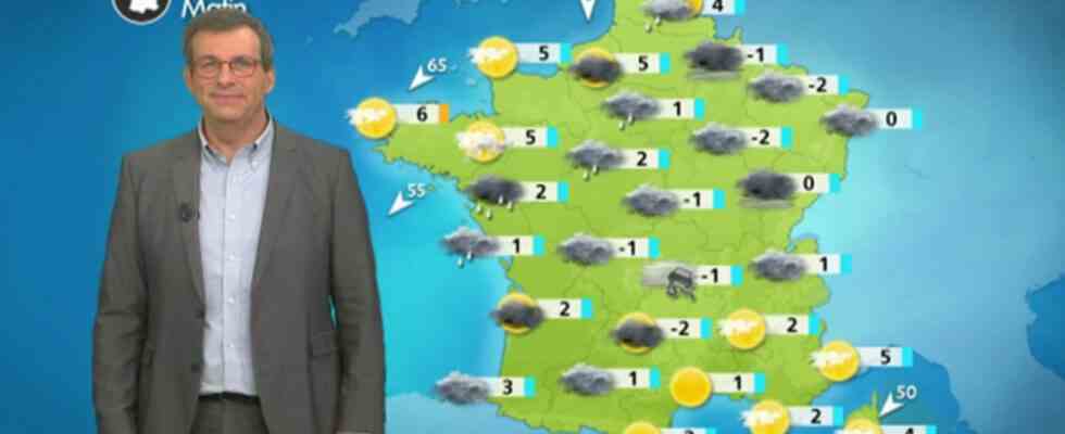
Details by region :
Of the Brittany and of Normandy to the Hauts-de-France, a disturbance brings some scattered rain in the morning with a little snow possible on the Avesnois and the east of Picardy. Very quickly, the clearings return via the west of Brittany and the Cotentin with a strengthening north-easterly wind. In the afternoon, a variable sky became widespread with rare showers from the Normandy coast to the Opal Coast.
Min: 1 to 5°C Max: 4 to 8°C
Of the Pays de la Loire and Centre-Loire Valley at France’s Island, intermittent light rains are circulating in the morning. They are sometimes preceded by snow in the east of Ile-de-France and the Centre-Val de Loire. In the afternoon, the weather remains gray and humid with sometimes a little drizzle or light showers.
Min: -1 to 2°C Max: 3 to 7°C
Of Great East to the Burgundy-Franche-Comte and in Auvergne-Rhône-Alpes, low clouds are again very numerous in the plains and valleys. A few drops or flakes may occur under the most dense clouds. You have to gain altitude to find the sun on the heights of the Alps and the Massif-Central.
Min: -2 to 1°C in the plain, but up to -13°C in the mountains Max: 0 to 5°C
In Occitania, PACA and Corsica, the sun dominates from Languedoc-Roussillon to the PACA region with mistral and tramontana between 70 and 80 km/h around the Gulf of Lion. In Corsica, the weather is more mixed with sunny spells and cloudy periods and still a low risk of showers. In the Midi-Pyrénées region, clouds dominate and small snowfalls occur intermittently from the Pyrenean foothills to the Tarn.
Min: -3 to 5°C Max: 3 to 13°C
In New Aquitaineclouds continue to occupy the terrain and some light precipitation may occur over the Limousin or near the Pyrenees with snow at very low altitudes.
Min: -1 to 4°C Max: 3 to 8°C
Subsequent trend
A flow from north to north-east will affect France this Friday with some snowfall possible down to the plains in regions close to the Pyrenees as well as in the center-east, which may leave a dusting of 1 to 3 cm on the ground. The weather will become dry again over a northwestern half of the country under the influence of the high pressure. Sun and wind will persist near the Mediterranean.