News Weather
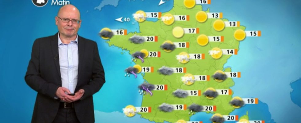
The weather is turning stormy from the west, be careful. Elsewhere, the heat is increasing a little more and it will often be 30°C this afternoon.
To remember :
– Alert issued from 3 p.m. for strong thunderstorms
– Strong rainfall and stormy deterioration over the Atlantic Arc this morning.
– Thunderstorms are marked on the northwest and southwest in the Alps in the afternoon and at night.
– Strong heat over the country, marked in the northeast
– The northeast wind remains strong in the English Channel (peaks 50 km/h)
– Chaotic sky from northwest to southeast
Evolution compared to the day before
The storms are developing this morning over the Atlantic arc, but are progressing faster and further towards the north of the country. Temperatures are rising with fairly high minimums on the Atlantic coast between 19 and 21°C. 31 to 32°C could be reached locally this afternoon. Stormy showers will sometimes be violent at night and during the day, from northwest to southeast.
Details by region
For the Normandy, Hauts-de-France and Île-de-France, The sky is clear to partly cloudy this morning. The afternoon is hot and heavy with a strong degradation envisaged on Normandy and the passage of thunderstorms and heavy rains in the afternoon. The south of Hauts-de-France like Ile-de-France will be on the edge of this disturbed system and could be impacted at the end of the day.
Min T°C: 15 to 17°C / Max T°C: 22 to 31°C
For Brittany, Pays-de-la-Loire and the New Aquitaine region, the sky is very cloudy to overcast this morning and it is raining with sometimes heavy precipitation. The sky is quickly becoming stormy this morning. The stormy showers will intensify in the afternoon in Pays-de-la-Loire and Brittany, then they will affect Normandy in the evening.
Min T°C: 17 to 21°C / Max T°C: 23 to 28°C
For the Great East, the day is calm, warm and sunny. A few threatening clouds move in at the end of the afternoon, but they only bring the moist feeling of the south. No precipitation is forecast. Temperatures will rise sharply and will often exceed 30°C.
Min T°C: 14 to 15°C / Max T°C: 28 to 31°C
For Occitania, it is already raining in Midi-Pyrénées, and a strong stormy degradation is coming from the south and west, with a possible line of convergence (line where winds from different sectors meet, favoring strong stationary stormy developments) between the sea air of hot southeast and the Oscar disturbance. This configuration will create a dynamic and thermal conflict zone and generate heavy precipitation that is not very mobile. There will also be hail locally and these intense precipitations in a short time can cause significant damage. So be careful, strong accumulations can cause flooding in a short time.
Min T°C: 16 to 20°C / Max T°C: 20 to 29°C
For Auvergne-Rhône-Alpes, the showers will be more numerous than the day before on the Alps. The sky is chaotic over Auvergne with a strong stormy degradation expected at the end of the afternoon and in the evening. Strong accumulations will be possible throughout the central massif and will overflow towards the Rhône valley in the evening.
Min T°C: 14 to 17°C / Max T°C: 24 to 30°C
For Provence-Alpes-Côte d’Azur and Corsica, the sky is veiled by clouds at altitude heralding the degradation of the weekend. The cumulus develop from midday, but will only give a few drops mainly on the reliefs. These showers will be fewer than the day before. The heavy stormy rains will overflow in the evening from Auvergne towards Provence.
Min T°C: 17 to 19°C / Max T°C: 23 to 27°C
Later evolution
The stormy degradation begins to progress towards the north of the country and will continue its journey by blocking the Alps. It brings numerous stormy showers which will give heavy accumulations of rain and allow the gradual drop in temperatures at the end of the weekend.
AT