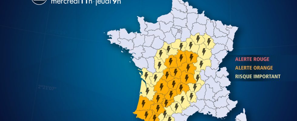
From Wednesday, June 21 at 11:00 a.m. to Thursday, June 22 at 9:00 a.m.
The complete live weather forecast by telephone at
3201*
Situation
France remains at the heart of an air mass conflict between warm subtropical air coming up from North Africa and cooler air coming in from the Atlantic. This situation is conducive to the development of active storm bursts moving up from the southwest to the north and northeast of the country. A new strong stormy deterioration is expected from this Wednesday afternoon and will continue until the following night with violent thunderstorms accompanied by intense rains, locally hail and strong gusts of wind.
Here are the main features of this special release:
– intense rains in a short time with an average of 20 to 30 mm under thunderstorms but locally up to 50-80 mm under the most active cells up to 100 mm possible in Limousin).
– significant runoff during the passage of heavy stormy rains with possible mudslides in certain agricultural sectors
– a risk of flooding in certain low points or urban districts
– a risk of overflowing of certain watercourses in Auvergne by accumulation on saturated soils
– a risk of hail 3 to 5 cm in diameter under the most violent storms
– violent gusts of wind of 80 to 100 km/h under the strongest thunderstorms
– a very localized risk of a vortex phenomenon
Observation
This Wednesday morning, a few stormy showers are still circulating between the southwest, the Massif-Central and Bourgogne-Franche-Comté. A few storm cells were also breaking out in Languedoc. They are gradually losing activity before the storms resume this afternoon.
Evolution
This Wednesday at middaya temporary lull is occurring on the storm front even if some thunderstorms can still occur in places from the Massif-Central to the northeast.
This Wednesday afternoon from 4 p.m., thunderstorms will multiply between Aquitaine and Limousin. They will be punctually strong with intense rains in a short time, locally hail and strong gusts of wind.
This Wednesday evening, thunderstorms will gain ground to the north and east, reaching Poitou, Berry, northern Auvergne and southern Burgundy. They may be particularly virulent from Limousin and Poitou to Auvergne with intense rains, a risk of gusts of more than 100 km / h, hail. On the Limousin, accumulations of 50 to 100 mm are possible.
On the night of this Wednesday to Thursday, the storms will continue to progress towards the north and northeast affecting the Center-Val-de-Loire, Champagne and Bourgogne-Franche-Comté. They will be strong at times with intense rains. The risk of hail and violent gusts of wind will mainly concern regions from the southwest to Burgundy. These storms will also partially cross Ile-de-France in the second part of the night (2 a.m. to 8 a.m.), in particular in the east of the region, which can cause heavy showers.
Here are the main features of this special release:
– intense rains in a short time with an average of 20 to 30 mm under the storms but locally up to 50-80 mm under the most active cells (locally 100 mm in Limousin).
– significant runoff during the passage of heavy stormy rains with possible mudslides in certain agricultural sectors
– a risk of flooding in certain low points or urban districts
– a risk of overflowing of certain watercourses in Auvergne by accumulation on saturated soils
– a risk of hail 3 to 5 cm in diameter under the most violent storms
– violent gusts of wind of 80 to 100 km/h under the strongest thunderstorms
– a very localized risk of a vortex phenomenon
List of departments concerned
- 03 – Combine
Thunderstorms – Orange Alert
- 09 – Ariege
Thunderstorms – Significant Risk
- 10 – Dawn
Thunderstorms – Significant Risk
- 12 -Aveyron
Thunderstorms – Significant Risk
- 15 -Cantal
Thunderstorms – Orange Alert
- 16 – Charente
Thunderstorms – Significant Risk
- 17 – Charente Maritime
Thunderstorms – Significant Risk
- 18 – Dear
Thunderstorms – Orange Alert
- 19 – Correze
Thunderstorms – Orange Alert
- 21 – Golden Coast
Thunderstorms – Significant Risk
- 23 – Dig
Thunderstorms – Orange Alert
- 24 – Dordogne
Thunderstorms – Orange Alert
- 31 – Upper Garonne
Thunderstorms – Significant Risk
- 32 – Gers
Thunderstorms – Orange Alert
- 33 – Gironde
Thunderstorms – Significant Risk
- 36 – Indre
Thunderstorms – Orange Alert
- 37 – Indre-et-Loire
Thunderstorms – Significant Risk
- 40 – Landes
Thunderstorms – Orange Alert
- 41 – Loir-et-Cher
Thunderstorms – Significant Risk
- 42 -Loire
Thunderstorms – Significant Risk
- 43 – Upper Loire
Thunderstorms – Significant Risk
- 45 – Loiret
Thunderstorms – Significant Risk
- 46 – Batch
Thunderstorms – Orange Alert
- 47 – Lot et Garonne
Thunderstorms – Orange Alert
- 48 – Lozere
Thunderstorms – Significant Risk
- 52 – Haute-Marne
Thunderstorms – Significant Risk
- 58 – Nievre
Thunderstorms – Orange Alert
- 63 – Puy de Dome
Thunderstorms – Orange Alert
- 64 – Pyrenees-Atlantiques
Thunderstorms – Orange Alert
- 65 – Hautes-Pyrenees
Thunderstorms – Orange Alert
- 71 – Saone-et-Loire
Thunderstorms – Significant Risk
- 81 -Tarn
Thunderstorms – Significant Risk
- 82 – Tarn-et-Garonne
Thunderstorms – Orange Alert
- 86 – Vienna
Thunderstorms – Significant Risk
- 87 – Haute Vienne
Thunderstorms – Orange Alert
- 89 – Yonne
Thunderstorms – Significant Risk