From to
Situation
The period of cold weather that began in early December ends between Sunday and Monday with a general warming.
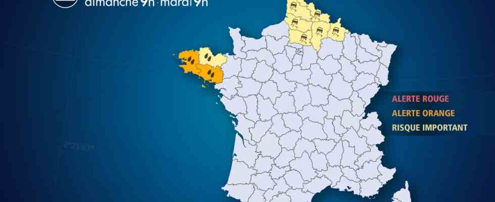
But this general thaw is accompanied by a major disturbance which undulates more than 48 hours over Brittany until Tuesday, causing heavy rains. The average quantities expected are between 50 and 100 mm, with maximums between 100 and 200 mm, i.e. an average of 3 weeks to 2 months of rain, which promises to be exceptional.
In a context of heavy seas with southerly waves of 3 to 4 m and strong south-westerly winds up to 90 km/h in gusts, the flow of rainwater could be hampered on the south coasts of Finistère and Morbihan and cause flooding of rivers (Odet, Aulne, Blavet, Laïta) causing flooding.
At the same time, this disturbance, on its arrival in the north-east of France this Sunday evening between 4 and 6 p.m., risks bringing an episode of ice. Indeed, these rains falling on icy ground will freeze immediately, hence a brief episode of black ice expected in Hauts-de-France in the Ardennes.
Observation
This Sunday
At 12 p.m., the rains increased over Finistère. Between 6 and 12 a.m., 24 mm of water fell at the Pointe du Raz (29), 20 mm at Pont l’Abbé (29) and Brest (29). Ice is reported in Normandy, between Orne and Calvados.
At 9 a.m., the rains have started in Finistère and are increasing rapidly. Over the past 2 hours, 12 mm of rain has been recorded at the Pointe du Raz (29). The wind strengthens and reaches 100 km / h in Ouessant (29). When these rains arrive on frozen ground, the ice is very present from Morbihan to the Côtes d’Armor this morning, before the thaw which has already reached Brest (29) where it is 8°C.
Evolution
Here are the characteristics of these bad weather
In Brittany
The rains set in this Sunday morning and will continue until Tuesday between Finistère and Morbihan, with some short temporary respites. These rains are expected to be long-lasting, of moderate intensity. Locally, the accumulations will exceed 150 mm of water in the center of Finistère and Morbihan in 48 hours. In a context of heavy seas with southerly waves of 3 to 4 m and strong south-westerly winds at 90 km/h, the flow of rainwater could be hampered on the south coasts of Finistère and Morbihan and cause flooding of rivers (Odet, Aulne, Blavet, Laïta) causing flooding.
In the Hauts-de-France and the Ardennes
The arrival of the disturbance results in a brief episode of freezing rain this Sunday evening. The rains falling on icy ground will freeze immediately, resulting in a delicate situation expected from Hauts-de-France to the Ardennes, between 4 and 6 p.m., before the rapid thaw during the night from Sunday to Monday.