Aelius Aristides was impressed. “(To Rome) is brought here, from every land and sea, whatever the seasons let grow and bring forth all countries, rivers and lakes as well as the arts of the Greeks and barbarians,” said the Greek speaker in 155 AD about the capital of the Roman Empire. “So innumerable are the barges that arrive here and carry all goods from all countries from every spring to every turn in late autumn that the city appears like a common trading center for the whole world.” What one could not see in Rome, Aelius Aristides concluded his remarks, that would not exist in the world either. Grain from Egypt, olive oil from the Baetica in the south of the Iberian Peninsula, exotic goods such as Irish hunting dogs, no wish was left unfulfilled in Rome’s marketplaces. “Globalization is really not a new phenomenon,” says the ancient historian Christoph Schäfer from the University of Trier. “The Romans already lived in a globalized world.”
The Roman Empire was a gigantic economic area. The same lingua franca was spoken practically everywhere, there was a single currency and the same legal system. As Aelius Aristides emphasized in his speech, the goods in this huge trade network were mainly transported by ship from one end of the Roman Empire to the other. But this poses a problem for the reconstruction of the ancient flow of goods. Because while the land transport leaves plenty of archaeological evidence in the form of roads, milestones or rest houses, the waves crash again after a ship and the sea looks as if nothing had happened. Although isolated shipwrecks and ancient reports give indications of the sea routes, their course is nowhere near as completely documented as the land routes.
Even in ancient times, time was money
To change that, Schäfer is pursuing the long-term project “Maritime connections and their influence on ancient sea trade”. For nine years, the scientists at the Trier Transmare Institute, together with other institutions, want to research the sea routes that made Rome a gigantic trading empire. You don’t have to start from scratch: “We can already build on almost 20 years of research,” says Schäfer. The ancient historian was already involved in the faithful reconstruction and testing of three Roman warships, a barge and a merchant ship. “In our project, historians and archaeologists work side by side with craftsmen, mechanical engineers, astrophysicists, computer scientists and economists.”
One of the latter is the independent consultant Pascal Warnking – who used his knowledge from the business world to check Roman trade routes for their profitability. Because nobody really wanted to believe the ancient authors when they reported about the speeds at which the Roman merchant ships supposedly traveled through the Mediterranean. For example Cato the Elder: “Besides, I am of the opinion that Carthage must be destroyed”, the Roman statesman is said to have demanded in every Senate session in the second century BC. To emphasize his concern, he once brought a bowl of figs to the lectern. At the end of his speech he held one of them up in the air and warned: “It was only picked three days ago in Carthage!” The Punic ships are said to be able to sail from Carthage to Rome that quickly. This statement has repeatedly been ridiculed by historians as showmanship. But: “Cato was right,” says Warnking.
Even in ancient times, time was money. Accordingly, the Roman investors were looking for optimized routes that promised them the greatest possible profit. Every additional day at sea cost the crew food – and possibly cost the ship one more voyage before the winter storms set in. The optimal route, however, depends on the season, weather conditions, winds and currents. Nowadays sea routes are calculated using nautical software that takes all of these factors into account. “Why shouldn’t that also work for ancient merchant ships?” Warnking wondered. He got himself “expedition” – regatta and navigation software that is also used in the Ocean Race, the America’s Cup and the Vendée Globe – and fed it with all available data from square sailors from all epochs of history that it could get hold of: Shepherd’s Roman ships, replicas of Viking boats from the Danish Roskilde, measurements of the French navy from the 18th and 19th centuries as well as the modern sailing training ship Gorch Fock. With regard to the weather, a fortunate circumstance helped: the very well documented Mediterranean climate in the 20th century corresponds almost exactly to that of the Roman Empire.
When Warnking checked the data, Cato’s dire prognosis became vastly more threatening. And another passage suddenly appeared in a new light. In his price edict, Emperor Diocletian (236/245 to 312 AD) stipulates the maximum transport costs for goods on almost 50 different sea routes. In the past, the apparently inconsistent requirements led ancient historians to dismiss the decree as an imperial miscalculation. But when Warnking fed his antique square sailer data into the regatta software, the calculated sailing times seamlessly explained Diocletian’s specifications. “That was my eureka moment,” says Warnking.
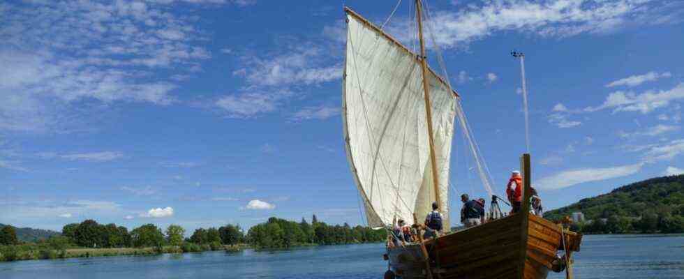
The replicated Roman ships are peppered with the latest measuring technology
While Pascal Warnking is the expert for the invisible with his route calculations, Christoph Schäfer has managed to make Roman seafaring not only visible, but also tangible. His ship reconstructions were built by students from the University of Trier and volunteers under the guidance of a specialist boat builder using ancient methods and craft techniques. The models were wrecks such as the merchant ship discovered in 1978 off the French coast near Marseille Laurons II.
But how does a Roman ship behave on the water? What is the fastest way forward? To answer these questions, Schäfer and his team, together with mechanical engineers from Trier University and astrophysicists from the Technical University of Hamburg-Harburg and MIT, have adapted and further developed a nautical measuring instrument. When the replicas do their test drives on the Moselle, they always attract attention. What hardly any of the spectators suspected, however, is that the hull and yard of the Roman ships are peppered with the latest technology, which constantly provides data on speed, movements and loads.
For professional nautical training, employees and students travel to the Netherlands and the Aegean Sea. But basic knowledge of rowing is also an advantage, because without muscle power, the river boats, which were just as much a part of the transport network as the big sailors, could not do anything. What is the maximum speed at which ships can be propelled by rowing, staking or towing? What cruising speed can a full crew of rowers in two different types of Roman warships keep for several hours? This can also be measured: in a test rowers kicked the two river warships Victoria and Lusoria Rhenana against each other while their lactate levels and heart rate were monitored – until they were completely exhausted.
“We are generating source material here that has never existed before,” says Schäfer. All new information flows into the heart of the project: the digital interactive maritime atlas on history, which is to be made available online. With it, scientists from all over the world can understand and simulate the broad lines of sea trade and the ancient economy for their own research projects. In any case, according to Schäfer, one thing is already becoming apparent: “The Roman economy seems much more modern than we ever imagined.”