
By Writing News
Published on
updated on 4 May 23 at 16:38
See my news
The sun and the heat, it won’t last. After an almost summery Wednesday, showers, often stormy, are coming to France from this Thursday, May 4, 2023. Météo France has placed 19 departments on yellow alert for thunderstorms this ThursdayAnd 45 departments are already on alert for this Friday, May 5, 2023.
- The departments concerned this Thursday, May 4 : Aisne, Calvados, Eure, Manche, North, Oise, Orne, Pas-de-Calais, Saône-et-Loire, Paris, Seine-Maritime, Seine-et-Marne, Yvelines, Somme, Essonne, Hauts-de-Seine , Seine-Saint-Denis, Val-de-Marne and Val-d’Oise.
- The departments concerned this Friday, May 5 : Ain, Aisne, Allier, Ardennes, Calvados, Cantal, Charente, Charente-Maritime, Corrèze, Creuse, Dordogne, Doubs, Eure, Eure-et-Loir, Gironde, Ille-et-Vilaine, Jura, Loire, Haute-Loire , Manche, Marne, Mayenne, Nord, Oise, Orne, Pas-de-Calais, Puy-de-Dôme, Bas-Rhin, Haut-Rhin, Rhône, Haute-Saône, Saône-et-Loire, Sarthe, Paris, Seine -Maritime, Seine-et-Marne, Yvelines, Somme, Haute-Vienne, Territory of Belfort, Essonne, Hauts-de-Seine, Seine-Saint-Denis, Val-de-Marne, Val-d’Oise.
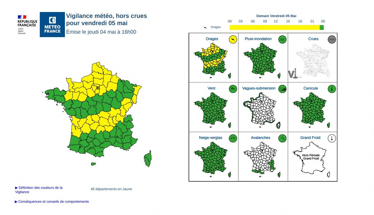
Thunderstorms and showers over almost the entire country in the coming days
From this Thursday morning, rain sprinkled the regions going from Brittany to Poitou-Charentes then these showers started from the coast of Normandy to Sologne, according to Météo France.
In the afternoon, the rain extends from the Loire estuary through Normandy to Flanders. These showers are initially not very active, then strengthen during the day, indicates the official service of meteorology and climatology in France.
In the evening, they also start from the Ardennes towards Lorraine, Burgundy and Auvergne where they also temporarily take on a stormy character.
And this strong stormy degradation will continue for the next few days. “France will be under the influence of a system of low Atlantic pressures which will affect almost all regions, with rainy and stormy weather on the menu”, explains to news.fr meteorologist Yann Amice.
Friday May 5, the storms should concern more of an area of the Massif Central in the Center-East during the day and Saturday May 6, a new stormy development is already in the sights, from the Pyrenees to the North-East.
Saturday May 6 is expected to be the most unstable day of the May 8 long weekend. “The stormy potential will undoubtedly be the strongest with higher ground temperatures and a little cold air at altitude”, estimates Yann Amice.
In the meantime, this Thursday, the temperatures are still very mild: 16 to 20 degrees in Brittany, 20 to 26 elsewhere with peaks at 26 or 27 at the foot of the Pyrenees and in the Rhône valley.
More info to come on actu.fr
Follow all the news from your favorite cities and media by subscribing to Mon Actu.