Status: 01/15/2023 5:40 p.m
The storm “Frederic” sweeps across Germany with hurricane-like gusts and heavy rain. There are warnings of a storm surge on the coasts. In the Harz mountains, cable cars are standing still. Levels are rising on the Moselle.
Hurricane-force gusts with heavy rain uprooted trees in large parts of Germany and affected shipping. Deutsche Bahn advises customers to find out whether and when the trains are running before they leave.
The Federal Maritime and Hydrographic Agency (BSH) warned of a storm surge on the coasts and islands. It is expected that the flood will rise a meter above the mean. the risk of storm surges is expected to last until 10 p.m. The gusts can reach wind speeds of 115 kilometers per hour. In the Weser area, too, the BSH expects the water to rise around one meter higher than the average high water level, on the Elbe one to 1.5 meters.
Beachgoers fight their way through the hurricane gusts in St. Peter Ording.
Image: dpa
Ferries stay in port
The ferry connections between Neuharlingersiel and Spiekeroog were brought forward, the Frisia Inselexpress to Norderney and Juist is canceled – the island ferries continue to commute. On pilot went overboard off the island of Borkum during a storm. He could be saved. On the Baltic Sea coast, the Scandlines shipping company canceled trips between Rostock and Denmark.
Pile-up near Oldenburg
A short and heavy sleet caused a suddenly icy road on the A29 south of Oldenburg at noon. Since nobody had expected the ice, there was a pile-up. A vehicle skidded on the slippery road, left the road and was thrown back. Four other vehicles were carried away. A total of six people were injured in the accident, and a helicopter was also called into action.
Hurricane-force gusts uprooted numerous trees in the Hamburg region and some fell on vehicles. The fire brigade was in constant use.
The fire brigade takes care of a fallen tree in Hamburg.
Image: dpa
Cable cars in the Harz are at a standstill
In the Harz region, the meteorologists expected rain between 30 and 40 liters per square meter. Numerous cable cars and lifts remained closed. The Lower Saxony State Forests warned against entering forest areas, especially in the higher elevations of the Harz Mountains and Solling. The dry summers of recent years have caused trees and parts of trees to die off, explained President Klaus Merker. The wind threatened to break them off.
A49 closed due to the risk of landslides
As a result of the constant rain in Hesse, the A49 between Neuental (Schwalm-Eder) and Schwalmstadt in the direction of Gießen was probably closed until Monday. According to the police, there was one at the level of the north portal of the Frankenhain tunnel in the immediate vicinity of the roadway landslide. There is a risk that earth could fall onto the road. A landslide was also reported in the Lahn-Dill district. Wetzlarer Straße (L3020) is closed in both directions between Solms-Niederbiel and Solms-Oberbiel.
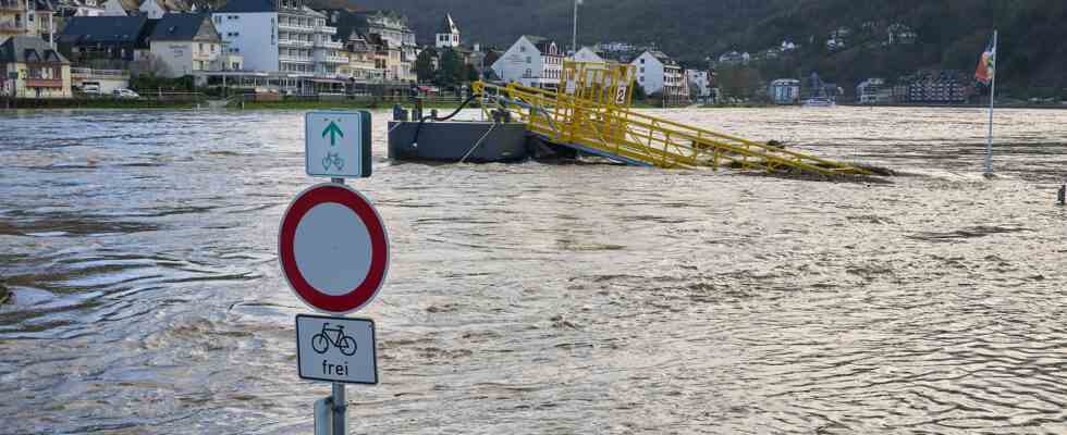
Flood on the Moselle
The water in the Moselle rose significantly due to the heavy rainfall. The water level in Trier was 6.44 meters in the morning, according to the flood reporting service of the State Office for the Environment. The trend is rising. For Monday, the experts expect that the Moselle will then remain at a level of around seven meters.
According to the police and fire brigade, some footpaths and cycle paths along the river were flooded. In addition, two roads in the Bernkastel-Wittlich district are closed due to the flood. These include the B53 between Machern Monastery and the bridge in Lösnich, as well as the K 134 between Lieser and Kesten.
Flooded meadows near Eichen in Wetterau, Hesse (aerial photo taken with a drone).
Image: dpa
Snow expected at the start of the week
At the start of the week announces itself winter weather on. A spokeswoman for the German Weather Service (DWD) in Offenbach said that the snow line would continue to fall in the coming days due to cold air. On Monday there will already be snow above 300 to 400 meters. “Especially in the Eifel, in the Hunsrück and in the Sauerland, there can be ten to 15 centimeters of fresh snow, in some cases even more.”
Snow cover could also form in the low mountain ranges. In addition, according to the DWD, rain is coming in from the west, while it remains dry in the south and south-east. In the west and in the middle, strong to stormy gusts are expected, in the southwest and in the mountains even gusts of wind. With temperatures between three and ten degrees, it is colder than in the past few days.