Not only Germany, but also large parts of Europe are affected by the violent wind and storms. In the Netherlands and Ireland, the storm claimed lives. In Amsterdam, for example, a person was killed by a falling tree on Friday afternoon, according to the fire brigade. A few hours later, a cyclist was killed by a tree in the south of the city. In Diemen in the east of the capital, a person died after a tree fell on his car.
The storm with hurricane-force gusts paralyzed public life in large parts of the country. Trees were uprooted, roofs torn off, trucks overturned. In The Hague, the wind blew off the roof of the football stadium. The extreme weather conditions also caused cancellations and delays at Amsterdam Airport Schiphol.
Even Ireland is hit hard. A man died there – also because of a falling tree. The storm cut off the power supply to around 80,000 households and businesses on the island. A number of flights from Dublin and Cork as well as ferry services have been cancelled. At times, wind speeds of 137 kilometers per hour were measured at the Roches Point lighthouse in the port of Cork.
There are also deaths in England. In north London, a young woman died in a car after a tree fell on the vehicle, according to police. A man died after debris fell on the windscreen of his vehicle in north-west England, according to local police. A young man also died in the south-east of the country.
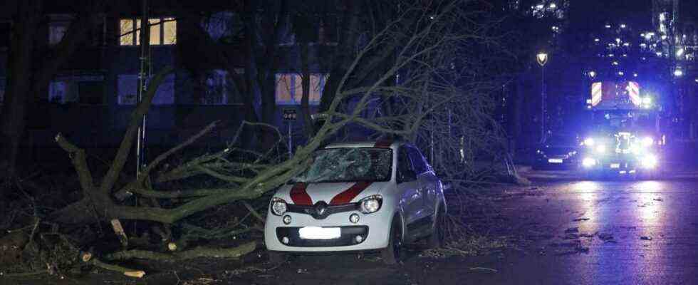
In Hamburg A tree also fell on parked cars, where a child was lucky: It was on its bike when the tree fell, as a police spokesman said, and survived with minor injuries. The subway in the Hanseatic city stopped operating on all above-ground routes.
the Donut The fire brigade declared a state of emergency. “Many things that are not secured are now flying around, for example at construction sites,” said a spokesman. In this case, a state of emergency means that so many alarm calls are received that they can no longer be processed one after the other – as is usually the case – but other priorities are set.
Because a construction crane in Aurich in East Friesland threatened to tip over, two single-family houses there have been evacuated. “He turned and tilted considerably, we also had to involve the construction company,” said a fire department spokesman. Because of the violent storm, around 70 operations were recorded in the Aurich district by the evening. There were more than 100 operations in the district of Leer, it was said. An oak crashed into a house in Aurich.
Devastation in Britain
The storm partially paralyzed public life in Great Britain on Friday and caused destruction. In London, the highest red warning level was declared for the first time. It also applied to parts of South West and South East England and Wales. Mayor Sadiq Khan urged people in the British capital to stay at home. The Met Office warned that there was a risk of death from flying debris.
Videos circulating on the internet showed how the covering of the Millennium Dome in the London Borough of Greenwich was partially torn away. Underneath the tent-like construction erected at the turn of the millennium is the O2 Arena, which often hosts music and sporting events. Train services in London have been partially suspended. storm depression Eunicethat in Germany Zeynep was baptized is considered one of the most severe storms to hit Britain in several decades. The highest wind speed ever measured in England was registered on the Isle of Wight at around 196 kilometers per hour, according to the weather service.
Dozens of flights have been canceled at Heathrow Airport and London City Airport. The Port of Dover has been closed following a string of ferry services. In Wales, train services were completely suspended on Friday. Tens of thousands of homes across the UK and Ireland were left without electricity. Roads and bridges were closed. Despite this, there have been reports of people getting dangerously close to shore defenses or even swimming into the sea. (02/18/2022)
DWD warns of danger to life from falling trees
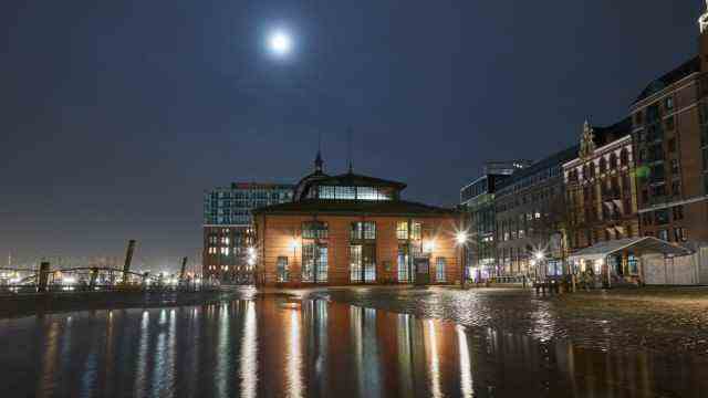
The Hamburg fish market was flooded again on Friday.
(Photo: dpa)
In Germany, experts warn of damage and accidents on all channels. “Everything that is on the terrace that is not nailed down is best brought in and put in the garage,” said Christopher Rehnert, head of the Lüdenscheid fire brigade, in the morning on ARD. Flower boxes or other items should be removed from balconies. The German Weather Service warned of extreme gusts of wind on the North Sea with up to 160 kilometers per hour from Friday afternoon. There is danger to life from falling trees.
“Close all windows and doors! Secure outdoor objects! In particular, keep your distance from buildings, trees, scaffolding and high-voltage lines! Avoid being outdoors if possible! Do not leave the house!” it said on the website of the DWD. (02/18/2022)
Bahn is gradually phasing out regional traffic in the north
Deutsche Bahn has gradually stopped operating in parts of northern Germany and North Rhine-Westphalia. Passengers can use their tickets booked for the period from Thursday to Sunday flexibly until February 27 or cancel free of charge if they postpone trips because of the storm. Deutsche Bahn asks its passengers to find out about their connection before they start their journey here to inform. There will also be delays and cancellations nationwide on Saturday.
Experts expect severe storm surge
A severe storm surge is expected on the German North Sea coast. For Hamburg reckon with water levels of three meters above normal high water; the highest level will probably be reached between five and six on Saturday morning, said Bernd Brügge from the Federal Maritime and Hydrographic Agency (BSH). However, this will not be a problem for flood protection facilities and dykes. Bruges recalled the storm surge of 1976, which reached 4.64 meters above the normal high water level in the Hanseatic city.
The A7 south of the Elbe tunnel was partially so badly flooded on Friday evening that at least one lane was blocked. A spokesman for the traffic control center said the lane could not be used before the water had been pumped out.
For Schleswig Holstein The BSH calculates in Büsum at 2.5 meters above normal high water, at the Eider barrier with 3.0 meters. Weather expert Frank Böttcher estimates the approaching storm at the upper limit of what is meteorologically possible on the coast. He could reach historical dimensions. According to Bruges, the fact that no higher storm surge is expected is due to the timing, among other things. The strongest wind field and the flood did not coincide in time. A very severe storm surge, starting at 3.5 meters above normal high water, is unlikely to occur. “We don’t see that at the moment,” Bruges said.
Also on the coast in Lower Saxony Coastal protectors expect high water levels on Saturday night. “We assume that we will have to deal with a severe storm surge,” said the spokesman for the Lower Saxony State Office for Water Management, Coastal Defense and Nature Conservation (NLWKN), Carsten Lippe. Due to the expected increased water levels, especially in the river funnels, barrages will be closed – probably also the large Ems barrage near Gandersum. The storm surge warning service of the state authority expects the flood on Saturday night to be between 2.25 and 2.5 meters higher than the average high tide. This means that the threshold according to the NLKWN definition of a severe storm surge is exceeded, said Lippe. (02/18/2022)
The storm hits the northern half of Germany in particular until Saturday morning
Zeynep could be even more severe than low Ylenia, which had led to train cancellations and at least two fatal accidents on Thursday. The focus of the new storm or even hurricane system will be the northern half of Germany until Saturday morning, predict the meteorologists of the German Weather Service (DWD). Parts of the states of Schleswig-Holstein, Hamburg, Mecklenburg-Western Pomerania, Bremen, Lower Saxony, Saxony-Anhalt, Brandenburg, Berlin, North Rhine-Westphalia, Hesse, Thuringia and Saxony are affected. (02/18/2022)
At least two dead by “Ylenia”
The storm low Ylenia claimed two lives. A 37-year-old man was driving in his car around nine o’clock in the morning on Thursday on the L252 between Bad Bevensen and Seedorf in the Uelzen district in Lower Saxony when a tree fell on his car and killed him. As a spokesman for the fire brigade confirmed, the driver died immediately. The country road was closed for the duration of the rescue work.
A 55-year-old died in a car accident on a country road in Saxony-Anhalt. A tree fell on the man’s car due to the strong wind, police said. As a result, the moving car overturned in the morning. The man died at the scene of the accident in the Mansfeld-Südharz district, it was said.
In Germering, Bavaria, a man was hit by a tree and taken to hospital with serious injuries. The 36-year-old is out of danger, the police said. The man walked to his car Thursday morning and was hit by the pine tree as he tried to get in. A woman noticed the unconscious man under the broken tree and called the police. The fire department removed the tree. (02/17/2022)
Hamburg fish market under water again
After the storm on Thursday, the Hamburg fish market was flooded again early Friday morning. According to the Federal Maritime and Hydrographic Agency, the water level at the St. Pauli measuring point was 1.49 meters above the mean high water level – one centimeter below the limit for storm surges. For Saturday, the BSH expects water levels of up to three meters above the mean high water, which corresponds to a severe storm surge. The maximum is expected to be reached early Saturday morning.
(02/18/2022)