If there were to be a third national park in Bavaria, it would be in an area where it makes sense. That’s what Michael Schmitt thought when the debate about such a new protected area picked up speed a few years ago. Schmitt was not convinced by the idea discussed at the time of declaring the Isar in the area between Munich and the mouth of the Danube a national park. This gave him the idea for his current research project “MapInWild”. Put simply, it’s about creating accurate, up-to-date maps of the Earth’s natural state using satellite imagery. And to be able to give a recommendation where another national park could make sense.
In September, Schmitt took over the newly created Chair of Earth Observation at the Institute for Astronautics and Use of Space at the University of the German Armed Forces in Neubiberg. If you will, his private and professional interests brought him to the project. “I am a hunter and fisherman who is also involved with the Isar fishermen’s association,” says the 37-year-old professor, who lives in Anzing in the Ebersberg district. As an angler and fly fisherman in particular, he viewed the idea of the Isar with suspicion, since use of the river is usually discontinued in German national parks and this could have resulted in a ban on fishing. It also lacked the areal spread that such protected areas normally have. So he combined his professional expertise with it: “As a representative of earth observation, I thought that a method could be developed that would enable discussion about which parts of the landscape are in need of protection, and that on a measurable basis.”
There have already been attempts to map wilderness areas. Methods were used that integrate different geodata. Among other things, maps were used that showed where there was a lot of electric light at night and thus human life. Population density maps were also used, as were land cover maps, which indicate where a forest or city is. What is new about the process that Schmitt and his team are working on: With the help of artificial intelligence, a method is to be developed that can create a naturalness index directly from satellite data. Data source should only be freely available satellite images from the EU program Copernicus.
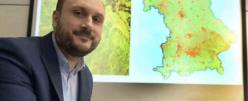
Dark green means “very natural”, red stands for “barely natural”
The advantage: The new method will lead to much faster results than previous techniques, since only a single current image is required. This would make it possible at any time to make up-to-date statements about the naturalness – i.e. the absence of human influences – of a certain place in the world. In addition, the maps created in this way offer a much higher resolution than the previous ones, some of which are one kilometer by one kilometer per pixel. “We need a higher resolution so that we can look at small countries and support nature conservation decisions there,” says Schmitt. The index rates the earth in the categories from “very natural” to “hardly natural”https://www.sueddeutsche.de/muenchen/landkreismuenchen/.”Very natural” appears in dark green and means that there is no human habitation there Influence gives, red color means “barely natural”.
In a first step, Schmitt and his team used existing maps to create naturalness maps for Bavaria, Scotland and Lapland, upscaling the resolution to ten by ten meters per pixel. Accordingly, Schmitt could well imagine a national park in the Ammer Mountains, for example, because the map for Bavaria shows a lot of dark green in this area. A positive side effect of the high-resolution and up-to-date maps: They can also provide information about possible risks from climate change. For example, if the naturalness map shows that the area around a river is now much more developed than it was ten years ago, it is clear that protective measures must be taken in the event of a flood, unlike if there were only untouched nature there. “But I would like to leave the use of the data to the experts,” says Schmitt.
As an engineer, the professor is not only interested in the nature conservation and social aspects of the project, which is scheduled to run until 2024, but above all in the technical aspects. Because the idea behind the project is also to learn to understand artificial intelligence better. It should be comprehensible how she makes her decisions, why, for example, the learned wilderness mapping models come to specific decisions. “We want to go beyond artificial intelligence as a black box where you put something in and you don’t know what will come out,” he says.
It is an exciting time for Schmitt, not only in terms of content, but also in terms of organization. He had studied at the Technical University of Munich, received his doctorate and qualified as a professor. After a year as a professor for applied geodesy at the Munich University of Applied Sciences, he was appointed to the Bundeswehr University last year. There he is still in the process of filling the chair with life. He already has a few doctoral students, more will be added in the spring, and one or the other piece of equipment still has to be purchased. “It’s all very satisfying because I can do things the way I want to.”