When she’s not climbing mountains, she gives lectures: the well-known high-altitude mountaineer Gerlinde Kaltenbrunner had already attempted several times to conquer the second-highest eight-thousander and the K2, which is considered extremely difficult. Years ago, Stefan Dech, Director of the Earth Observation Center of the German Aerospace Center (DLR).
That evening, the professor had the idea that the flanks of K2 should be able to be mapped more precisely with the help of the most modern satellite data: three-dimensionally, from very different perspectives and in a quality that has never been achieved before. “We will be able to see any position on the mountain, any ascent route and all the subtleties,” says Dech. “Then we can also climb the K2 virtually on all routes. That could also help Gerlinde on her next attempt.”
Completely new visualization of the mountains
His idea: when flying over a satellite, three shots are taken in succession from different space perspectives, a so-called triple stereo image. But the camera systems of the earth observation satellites are designed more for settlement areas, cities and agriculture, less for the strong contrasts of dark rock and light snow in the high mountains.
The DLR scientists therefore had to find new ways and intervene in their “payload management” together with the operators of the US satellites. But even the first shots in a cloudless sky delivered successful results. In the animation laboratory, the photos were superimposed and calculated.
At the beginning of July 2011, siaen Kaltenbrunner and her team at the DLR Earth Observation Center in Oberpfaffenhofen on the computer and look through 3D glasses at the north side of K2, where they want to set up their base camp two weeks later. The alpinists virtually assess the details and the key point on the flank of the summit. “Surprisingly, this part is much less steep than feared, so it seems doable,” says Kaltenbrunner.
Just a few weeks later, on August 23, the mountaineer stood on the summit of K2, also thanks to the help of the new DLR maps. Gerlinde Kaltenbrunner has thus climbed all 14 eight-thousanders – as the first woman to do without additional oxygen from a bottle.
The fourth dimension in mountaineering
Encouraged by the success of the summit, further images of mountain landscapes are created using the stereo-photogrammetric method with satellite data – and the desire grows to publish the photos of the highest accuracy in a book: “m4 Mountains – The Fourth Dimension”is the title of the illustrated book that Malik has appeared.
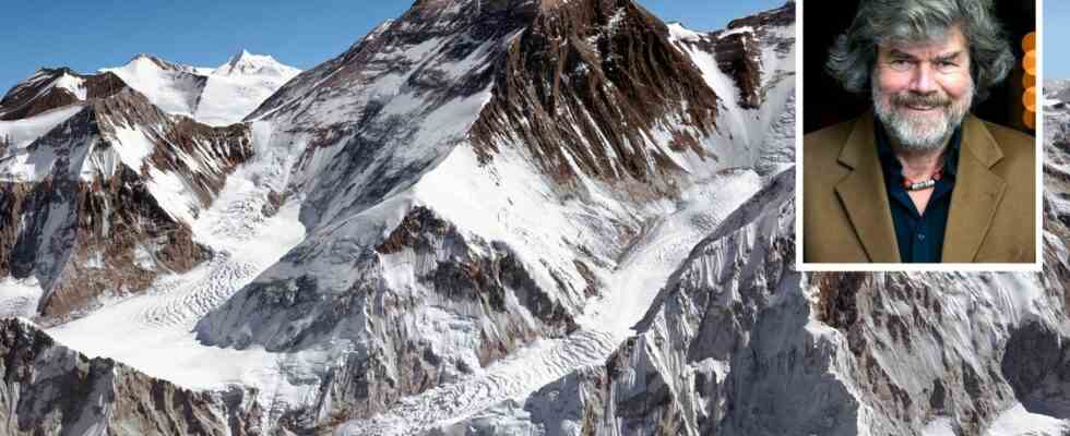
The unique shots of the 13 high mountains are combined with 13 stories about the history of their ascent. The text contributions were selected by Reinhold Messner, among others. “The satellite images from DLR gave me the opportunity to tell the mountains in a completely new way,” says Messner.
The illustrated book is not only a stroke of luck for alpinists, but also for all mountain enthusiasts. Whether it’s the Matterhorn or Mount Everest, the photos together with the gripping stories give the mountains a fourth dimension: it’s the achievement of the mountaineers that can be experienced almost up close. Rarely has there been such a symbiosis of scientific curiosity and enthusiasm for mountaineering.
Also read:
– Everest ascent: corpses pave the way to the summit
– Mount Everest degenerates into the highest garbage dump in the world
– #Project360 in the Himalayas Now everyone can climb Everest
This article contains so-called affiliate links. Further information are available here.